
A
NEW PLAN FOR GREATER LONDON
Hugh Clout
Professor
of Geography
Dean of the Faculty of Social and Historical Sciences
University College London
A Lecture
given at the University of Rouen,
on the invitation of Dr Françoise Lucchini,
Senior Lecturer at the Laboratoire MTG : Modélisation et Traitements
Graphiques en Géographie
and Professor Michel Bussi, Head of the Department of Geography,
on 9 April 2003

Greater London has a long tradition of metropolitan planning but has experienced considerable challenges of metropolitan administration in recent decades. Building on the heritage of the London County Council (LCC), the Greater London Council (GLC) was established in 1965 and functioned for two decades until 1986 when it – and other metropolitan councils – was dissolved at the wish of the Conservative government (i.e. Mrs Thatcher). Beneath the level of the GLC there were (and remain to this day) a total of 32 London Boroughs plus the City of London. These London Borough Councils are elected authorities and have the day-by-day responsibility for the running of their areas.
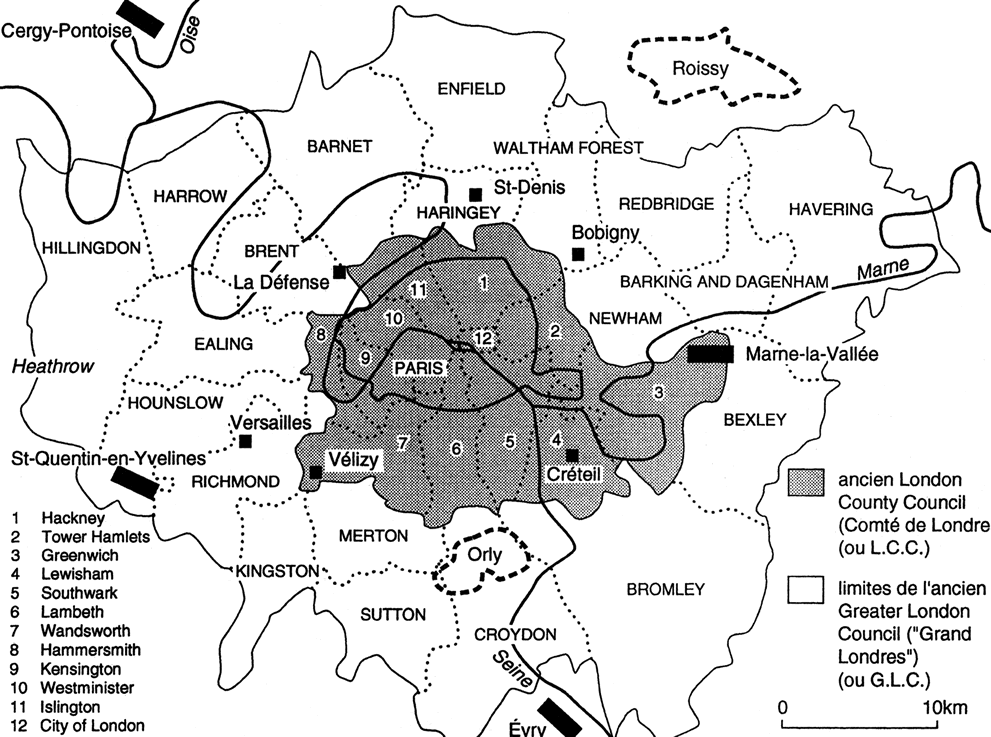
Figure 1 shows the London Boroughs superimposed on a map of greater Paris drawn at the same scale. (A summary of the Plan may be found at http://www.london.gov.uk/approot/mayor/strategies ).
The GLC had a strategic, coordinating role that was clearly necessary for a vast metropolitan area. Under the present Labour government the notion of an elected mayor for the whole of Greater London was advanced and the Greater London Act of 1999 re-established the 'Greater London' area (=GLC) and introduced the new idea of an elected mayor for Greater London. Mayors continue to be elected for each of the London Boroughs. Ken Livingstone was elected as Mayor of Greater London (with population of ca. 7,500,000) and councillors for Greater London were also elected. Under the Greater London Act, the Mayor is required to produce a Spatial Development Strategy (or 'Plan') that will replace existing strategic guidance for the city-region.
This 'London Plan' appeared in draft form in June 2002. It benefited from the active input of the geographer-planner Sir Peter Hall and the architect-planner Sir Richard Rogers. It deals with matters of strategic importance for London as a whole and is also charged to take into active consideration:
- the future health of Londoners
- equality of opportunity for London’s inhabitants
- the future contribution of London to sustainable development
The London Plan will:
- offer a strategy for integrating social, economic and environmental issues for the next 15-20 years
- integrate the Mayor's other responsibilities, notably for public transport, land-use management and other aspects of infrastructure
- provide the framework to which the London Boroughs must relate their local plans
- involve the Mayor and the Greater London councillors in strategic planning
- set out proposals for implementing and funding innovations
- provide London's response to European Union guidance on spatial planning and structural funding
The Draft Plan argues that it "will enable a strategic approach to be taken to the key issues facing London" (page vi) and will:
- provide a clear framework within which all of the stakeholders in London's future can plan their own activities to best effect
- enable Londoners to participate in shaping the future of their city
- ensure that policies are coherent and integrated, across issues and between places
- send a strong message to the world that London has a vibrant and confident view of its future
The Mayor has defined his key objectives in the following terms:
- making the most sustainable and efficient use of space in London; encouraging intensification and growth in areas of need and opportunity
- making London a better city for people to live in
- making London a more prosperous city with strong and diverse economic growth
- promoting social inclusion and tackling deprivation and discrimination
- improving London's transport
- making London a more attractive, well-designed and green city
Figure 2 indicates the most deprived 20% of census areas in Greater London, based on combined indicators of poverty, unemployment, educational attainment, health conditions, and quality of housing. It is arguably the most problematic and challenging map in the whole Plan. To cope with matters of exclusion demands not only improvements in infrastructure and environmental conditions but also many more changes that need to reach deep into social and economic inequality.
What key changes have taken place in Greater London over the last few decades? The Plan recognises six major forces driving change:
- population
- economy
- environment
- lifestyle
- technology
- social justice
"Each has roots in global changes, with a particular London dimension" (page 15).
The total population of Greater London has grown steadily since the late 1980s, currently standing at 7.5 million and likely to reach 8.1 million by 2016. In other words, having absorbed the equivalent of the population of Sheffield in the last 15 years, London is expected to grow by the equivalent of the population of Leeds in the next decade and a half.
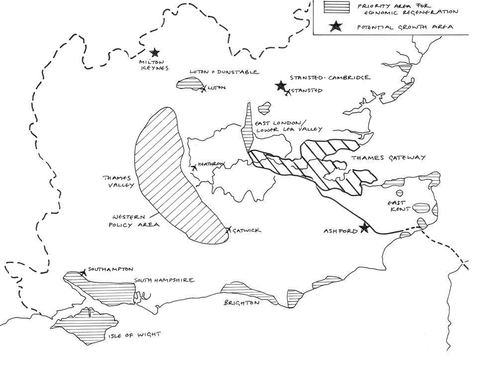
The trend of population growth has been characterised by "more young people, many more black and ethnic minority communities, and more young newcomers from across Europe. Whilst overall wealth has increased, so has the disparity between rich and poor" (page 15) in the post-industrial, service economy of the metropolis. And again: "Inequality has grown dramatically over the last 25 years. One of the aims of this plan is to contribute towards a more equitable distribution of the benefits of economic growth" (page 31). The point is stressed repeatedly in the Plan, which also looks outward to the wider metropolitan region of South-East England with a total population exceeding 18 millions. Figure 3 indicates London at the heart of this larger metropolitan region.
Results of the 2001 Census presented the social and ethnic complexity of London with startling clarity. For example, 27% of Greater London’s residents have been born outside the U.K. People of Black or Asian origin comprised 61% of the total residents of the London Borough of Newham (in East London) and 55% of the London Borough of Brent (in N.W. London). In 16 other London Boroughs more than a quarter of the total residents were of Black or Asian origin. Immediately to the west of the GLA, 37% of the population of the town of Slough was characterised as Asian. The diversity of 'Londoners' stands in striking contrast with north-east England which contains several municipalities where 99% of residents are 'white' (http://www.nationalstatistics.gov.uk/census2001/ ).
More people and more (and smaller) households in Greater London will require more housing and more land for housing and for the installation of employment facilities. In this respect, the Plan looks emphatically at the re-use of abandoned former industrial and railway land ('brownfield sites') and the possibility of steering a substantial proportion of future growth to the relatively deprived east of London, through the former docks and ex-industrial suburbs into the so-called 'Thames Gateway' on both sides of the Thames Estuary. This is a concept from Sir Peter Hall that has found favour with both Conservative and Labour politicians. In addition, 'growth potential' has been identified along the 'London/ Stansted airport/ Cambridge corridor' and the 'Western Wedge' of London extending upstream into the Thames Valley (Figure 3). All these strategic visions will require sensitive coordination with the local authorities outside the Greater London Area.
Spaces and Places
As suggested already, over the past decade London has started to experience a rapid build-up in population and jobs - although they both remain below historic high points. "All London Boroughs (with the exception of [rapidly de-industrialising] Barking and Dagenham, and Havering) have seen their populations increase over the past decade" (page 49). However the growth of employment over that period has been especially pronounced in the centre of the metropolis and to the north-west. 'Opportunity Areas' offer space for new housing and employment in the form of 'intensification' (ie increased densities of activity) and 'regeneration' (i.e. new uses of 'brownfield sites' and the challenge of tackling social exclusion). These socio-spatial considerations are complemented by an awareness of the need for 'sustainable growth' with considerable environmental awareness. A new feature in the Plan is the 'Blue Ribbon Network' of rivers, canals, lakes and reservoirs that "comprises semi-natural and man-made [water] systems that are both a resource and subject to natural forces. Development and use of the water and waterside land should respect these resource considerations … in order to ensure that future development and uses are sustainable and safe" (page 68).
Central London
Here the Plan identifies areas of potential intensification (Euston, Farringdon/Smithfield, Holborn, Tottenham Court Road, Victoria) and areas of opportunity (Elephant and Castle, Kings Cross, London Bridge, Vauxhall and Nine Elms, Battersea, and Waterloo). The latter include a range of sites of former railway, industrial or warehousing land where innovative land uses will be possible.
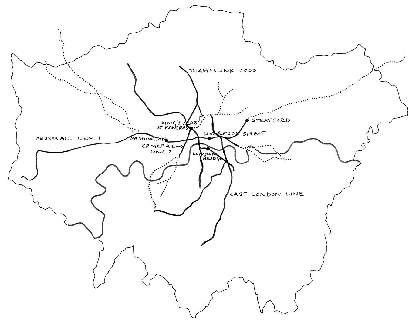
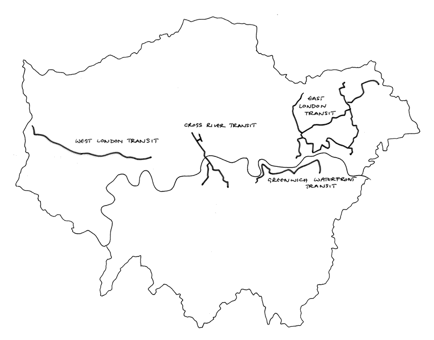
In order to facilitate the movement of commuters into and through Central London a number of highly expensive proposals for improving public transport are advanced. (In fact, most of these are revised versions of schemes that had been discussed in earlier years). Figures 4 and 5 show the proposed new rail lines and light transit systems.
- Crossrail involves the excavation of a deep railway tunnel running east-west under central London to join surface railway lines currently terminating at Paddington on the west and at several stations on the eastern side. Intermediate stations are proposed at Bond Street, Tottenham Court Road, Farringdon and the Isle of Dogs. A completion date of 2011 is suggested.
- Thameslink 2000 involves the elaboration of a north-south rail link through tunnels; a completion date of 2008 is suggested
- Crossrail involves the excavation of a deep tunnel aligned north-east to south-west from Dalston to Victoria, with intervening stations at Kings Cross (serving the new terminal of the Channel Tunnel Rail Link/ Eurostar services), Tottenham Court Road, and Piccadilly Circus. A completion date of 2016 is advanced.
- Cross-river Transit, with a proposed completion date of 2011, seeks to improve passenger transport between Kings Cross and Euston in the north, and Waterloo and Elephant and Castle in the south.
West London
Here developments are proposed around Heathrow airport, and former industrial land at Park Royal, Wembley and White City.
North London
Available post-industrial land is identified at Brent Cross (along the North Circular Road) and in sections of the Lee Valley extending from Tottenham Hale northwards.
South London
'Brownfield' sites remain at Croydon and Colliers Wood for further use.
East London
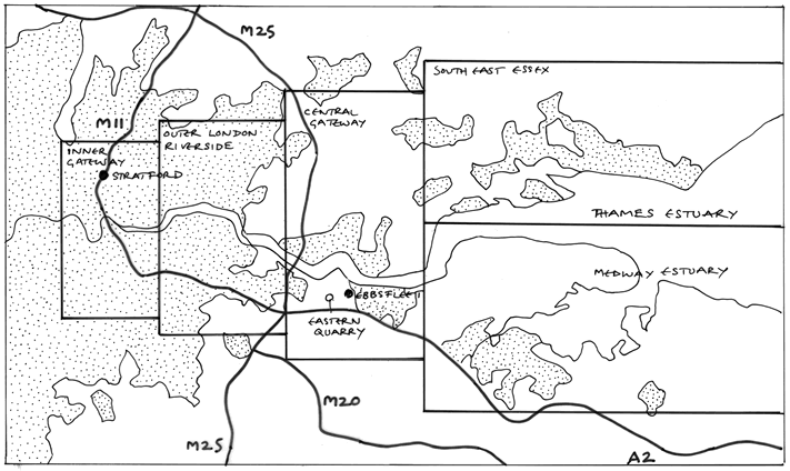
This involves by far the most ambitious set of proposals both for ‘brownfield’ sites within the existing built-up framework of London (Lower Lee Valley, including the new station on the Channel Tunnel Rail Link at Stratford) and many sites extending through the 'Thames Gateway', incorporating the Royal Docks, post-industrial sites at Barking and Dagenham, and many other sites extending downstream on both sides of the Thames Estuary that are shown on Figure 6.
Detailed proposals for new housing and employment in the 'Thanes Gateway' will be highly dependent on the improvement of public transport (rail). Five zones of potential expansion are recognised:
- Inner East London (48,000 extra dwelling units, and 213,000 additional jobs proposed by 2015)
- Outer London Riverside (27,750 extra dwellings; 8,600 extra jobs)
- Ebbsfleet and Mid-Gateway City (to be served by a new station on the Channel Tunnel Rail Link)(47,300 extra dwellings and 51,600 extra jobs).
- Medway City (40,610 new dwellings, and 31,000 extra jobs).
- South Essex Towns (15,900 extra dwellings, 21,000 additional jobs).
These are mightily ambitious and expensive proposals that will require extremely efficient public transport links, effective water management (since many are low-lying areas potentially exposed to flooding - as in the disastrous floods of 1953), and sensitive planning and design of new settlements. The Plan places great stress on the need to establish "sustainable communities" both in social and ecological/environmental terms. Already, nature conservationists have expressed extreme opposition to proposed developments that will have seriously damaging impacts on some /all of the 42 Sites of Special Scientific Interest within the Thames Gateway perimeter and on the European Union Special Protection Area on the southern shore of the Thames. A highly controversial international airport has been proposed at Cliffe Marshes in Kent, a deepwater container port at Shellhaven, and an additional bridge across the Lower Thames that will bring traffic, pollution and potentially also land-use development to relatively empty stretches of marshland. The ecological importance of the marshes of the Lower Thames as a suite of habitats for migrating birds cannot be overemphasized. A recent flight over the Thames estuary brought home both the unspoiled nature of much of the area and the very real threat of flooding, with extensive areas of grazing land being interspersed with stretches of standing water.
A specific example of a proposed new housing and employment development involves the sensitive re-use of the vast Eastern Quarry (formally used for excavating chalk for use in cement manufacture). The proposal is to insert five villages, providing 7,250 homes, and employment opportunities for 10,000 people in this enormous quarry that has been closed for almost a century. The site is close to Ebbsfleet Station (on the Channel Tunnel Rail Link) that will bring Central London (St Pancras) within 20 minutes travelling time and allow access to Paris in a fraction over 2 hours (see Figure 6). Closer to central London, the proposals for the eastern side of London include installing 10,000 new homes and a 26,000-capacity entertainment and sports facility on the Greenwich peninsula, the site of the controversial 'London Dome' constructed for the Millennium celebrations.
Essential Requirements
As well as identifying sites for innovation, the Plan stresses the following essential requirements for the future.
1. Additional housing, and especially the provision of extra medium-cost 'affordable' housing is essential. The housing market in greater London and the South-East is highly inflated (in part as a result of the high pay given to certain financial employees) making house or apartment purchase an impossibility not only for young people but also for those on relatively low wages (including many essential workers in public services - teachers, nurses, firemen etc). The Mayor's Plan advances the inclusion of a sizeable proportion of 'affordable housing' in each development and also emphasises the controversial notion of creating 'compact' housing schemes that will provide essential accommodation, while conserving as much land as possible. Critics have been very concerned at this notion, fearing that 'compact' and 'affordable' will add up to 'poor quality and bad design'. However the experience of new urban schemes in the Netherlands, for expansion in the recent expansion of Maastricht, demonstrate what can be achieved by way of compact development
2. Health-care provision is being rationalised and will involve the closure of some smaller hospitals, expansion of larger hospitals (serving wider catchment areas), and release of some surplus land for redevelopment.
3. Education (essentially primary and secondary schooling, rather than higher education) needs investment and improvement.
4. Social inclusion, involving the respect of and support for London's highly diverse communities (ethnic and sexual minorities) is identified as a guideline.
5. Existing neighbourhoods need to be recognised and supported in terms of shopping provision, social facilities and transport.
6. Burial space needs careful consideration since available sites are running out and long-established cemeteries require careful and costly maintenance (having, of course, an important ecological/environmental significance as 'green' open space for a sustainable city).
Biodiversity
The final sections of the Mayor's Plan place notable stress on environmental concerns alongside proposed innovations in public transport and land use. To be functionally viable in the 21st century, Greater London requires highly controversial improvements in motorways and rail links to ports and airports, increased runway capacity at major airports (Heathrow, Gatwick, Stansted), coordinated orbital rail services, and a new light transit/tramway routes (see Figure 3). These will have enormous impact on the environment and have been roundly criticised by many local residents and environmental groups. Doubtless, the controversy will continue vigorously!
The Plan seeks optimistically to reconcile sensitive development with wise conservation, playing particular stress on the Mayor's responsibility "to protect, mange and enhance biodiversity… in support of the Biodiversity Strategy". Emphasis is placed on:
- The metropolitan and global context of air, energy, water quality, noise, and climate change
- The need to recycle waste and develop renewable energy sources
- The need to restore contaminated 'brownfield' sites for future uses
- The desirability of extending cycling and walking routes within the metropolitan area as a healthy alternative to using cars or public transport
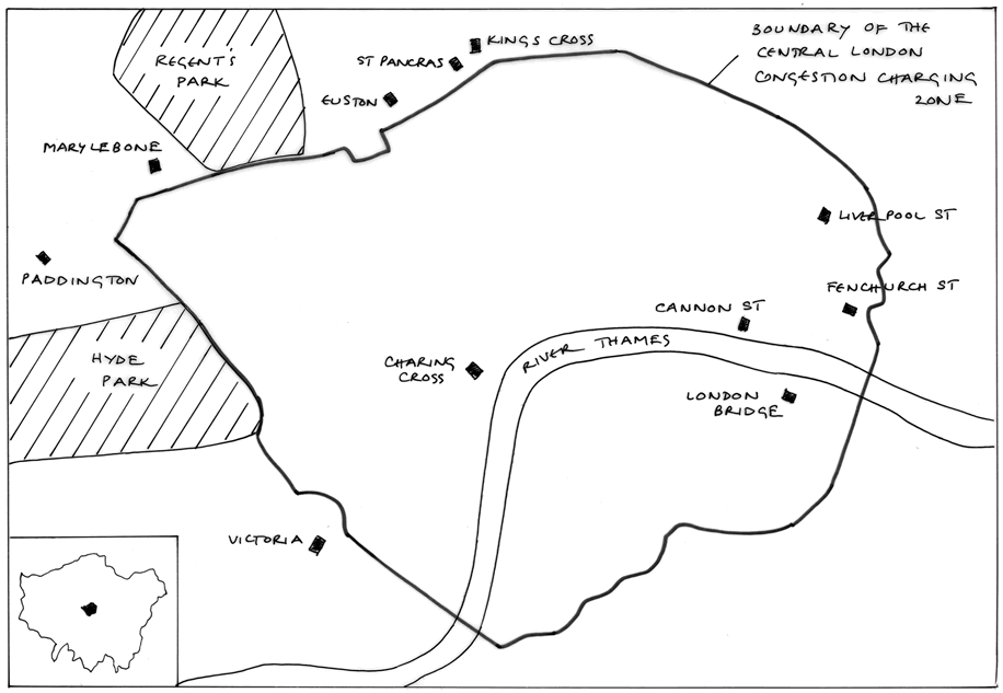
In the spirit of environmental improvement, in Spring 2003 the Mayor introduced the highly controversial 'congestion charge' for private cars and vans in central London. Figure 7 indicates the area affected. A charge of £5 per day is levied on vehicles entering the central area between 07.00hrs and 18.30 hrs on working days (Monday - Friday). There is no charge at the weekend. The overall effect appears to be a slight reduction in the volume of traffic in the city centre but increased congestion (and slower movement) along certain routes beyond the perimeter of the congestion charge zone as vehicle drivers seek out routes to avoid payment.
A Final Review
1. The Mayor's Plan offers a clearly written and well-illustrated summary of recent socio-economic changes and future challenges in Greater London. Information is up-to-date and there are excellent maps and photographs in the volume of more than 350 pages.
2. The Plan contains a suite of proposals for the future, many of which are highly contentious and extremely expensive. Only time will tell what proportion will be realised and at what cost.
3. The Plan certainly pays attention to the ecological/environmental issues that will have to be faced; arguably, these are more manageable than the fundamental problems of social exclusion and cultural inequality that are very apparent among 'Londoners' at the start of the 21st century.
4. However, when compared with successive master plans (schémas directeurs) for Greater Paris (Ile-de-France), the Mayor's Plan for London advances nothing that is genuinely new once an international perspective is introduced.
After all this discussion of infrastructural projects and ambitious schemes, it is apposite to conclude with the vision and the social awareness of Sir Richard Rogers in his Foreward to the Plan.
"Urban renaissance is about making the city a place where people want to live, rather than a place from which they want to escape.
A successful and sustainable city needs to be both beautiful and environmentally responsible, both compact and polycentric, with distinctive communities and neighbourhoods.
But, above all, it must be a fair city, respecting and celebrating the diversity of its people.
Paradoxically, London, amongst all the world's richest cities, has acute disparities of wealth and opportunity.
Wide areas of inner and east London are the largest concentration of urban deprivation in Western Europe. Over 40% of London's children live in households below the official poverty line."
To complement this final message, please look again at the pattern on Figure 2 that shows the most deprived areas in London, but of course impoverished people, poor living conditions and limited life chances are found throughout the capital, often cheek-by-jowl with wealth and privilege. Averages distort the complexities of London’s fundamental human problems.